Tiedosto:NorthSeaCurrents.png
Siirry navigaatioon
Siirry hakuun
Tämän esikatselun koko: 458 × 599 kuvapistettä. Muut resoluutiot: 183 × 240 kuvapistettä | 367 × 480 kuvapistettä | 587 × 768 kuvapistettä | 783 × 1 024 kuvapistettä | 1 300 × 1 700 kuvapistettä.
Alkuperäinen tiedosto (1 300 × 1 700 kuvapistettä, 3,43 MiB, MIME-tyyppi: image/png)
| Tämä tiedosto on tiedostotietokanta Wikimedia Commonsista. Tiedot kuvaussivulta näkyvät alla. |  |
Tiedoston kuvaussivu Commonsissa |
Yhteenveto
| Kuvaus |
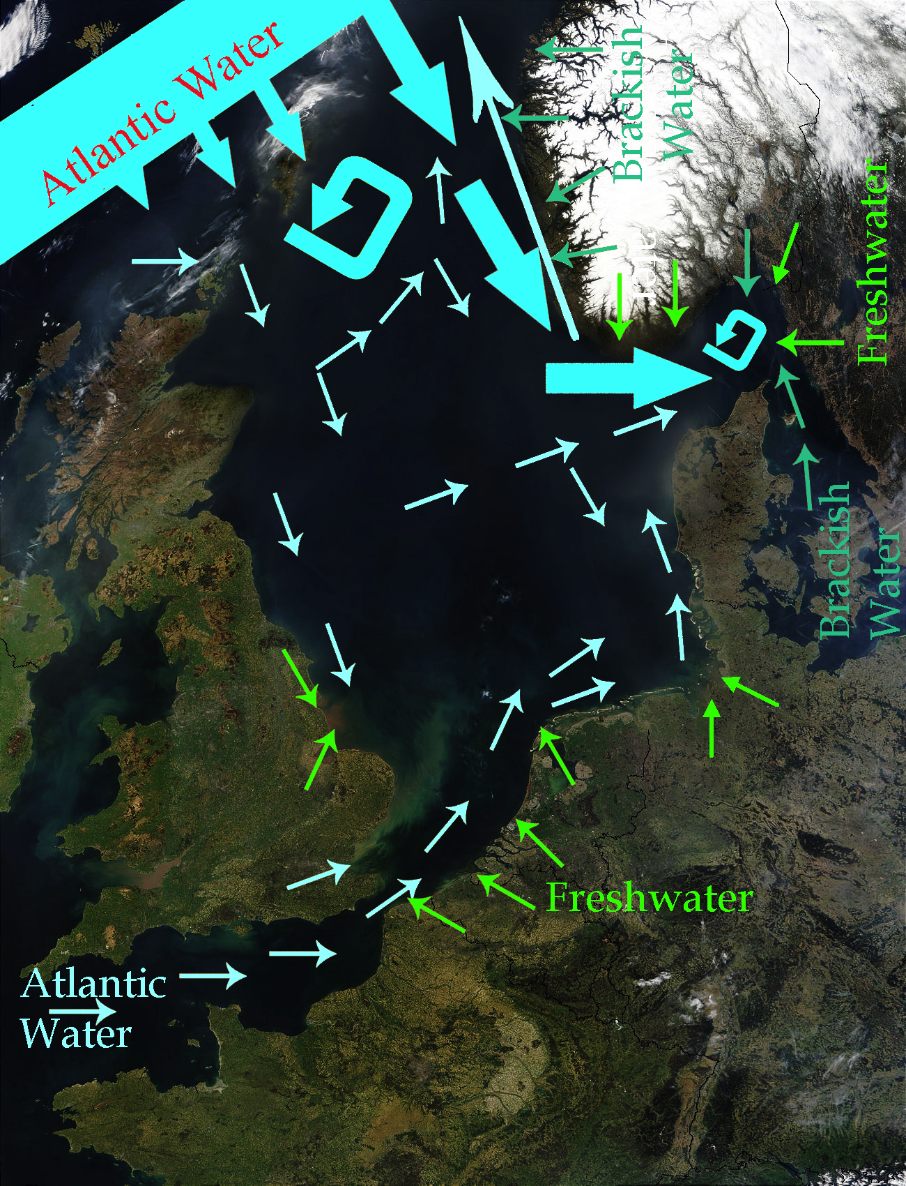
English: North Sea Map derived from NASA satellite image. This image depicts the currents in the North Sea. The intensive light blue broad arrows show the current and amount of flow from the Atlantic Ocean entering the northern area of the North Sea The smaller pale yellow arrows represent the current from the Atlantic Ocean entering through the English Channel. The bluish green arrows represent brackish water from fjords and the Baltic Sea. The green arrows represent freshwater from various rivers which drain land areas and discharge into the North Sea. Sources used to base this map upon were Safety at Sea currents and North Sea physiography (depth distribution and main currents) Guide to the Oceans By John Pernetta page 184 It would be nice to re-do this map with wiggly flowing arrows for the water currents. |
| Päiväys | 2009-01-22, recoloured in 2014-04-27 |
| Lähde | Derivative work from File:NASA NorthSea1 2.jpg |
| Tekijä | SriMesh, recoloured by Ulamm (talk) 22:29, 27 April 2014 (UTC) |
| Muut versiot |
• File:North-Sea-Labels.jpg • NorthSeaCurrents,jpg, the original presentation of the currents |
Lisenssi
Minä, tämän teoksen tekijänoikeuksien haltija, julkaisen täten tämän teoksen seuraavilla lisensseillä:
Tämä tiedosto on lisensoitu Creative Commons Nimeä-JaaSamoin 3.0 Ei sovitettu -lisenssillä.
- Voit:
- jakaa – kopioida, levittää ja esittää teosta
- remiksata – valmistaa muutettuja teoksia
- Seuraavilla ehdoilla:
- nimeäminen – Sinun on mainittava lähde asianmukaisesti, tarjottava linkki lisenssiin sekä merkittävä, mikäli olet tehnyt muutoksia. Voit tehdä yllä olevan millä tahansa kohtuullisella tavalla, mutta et siten, että annat ymmärtää lisenssinantajan suosittelevan sinua tai teoksen käyttöäsi.
- jaa samoin – Jos muutat tai perustat tähän työhön, voit jakaa tuloksena syntyvää työtä vain tällä tai tämän kaltaisella lisenssillä.

|
Voit kopioida, levittää ja/tai muuttaa tätä asiakirjaa GNU Free Documentation License -lisenssin version 1.2 tai minkä tahansa Free Software Foundationin julkaiseman myöhemmän version ehtojen alaisena; ei koske muuttumattomia kohtia, etukannen tekstejä eikä takakannen tekstejä. Kopio tästä lisenssistä on saatavilla osiossa GNU Free Documentation License. |
Voit valita haluamasi lisenssin.
Tiedoston historia
Päiväystä napsauttamalla näet, millainen tiedosto oli kyseisellä hetkellä.
| Päiväys | Pienoiskuva | Koko | Käyttäjä | Kommentti | |
|---|---|---|---|---|---|
| nykyinen | 28. huhtikuuta 2014 kello 01.56 | | 1 300 × 1 700 (3,43 MiB) | Ulamm | once more |
| 28. huhtikuuta 2014 kello 01.48 |  | 1 300 × 1 700 (3,47 MiB) | Ulamm | more freshwater arrows | |
| 28. huhtikuuta 2014 kello 01.29 |  | 1 300 × 1 700 (3,47 MiB) | Ulamm | == {{int:filedesc}} == {{Information |Description={{en|1=''North Sea Map'' derived from NASA satellite image. This image depicts the currents in the North Sea. The dark yellow broad arrows show the current and amount of flow from the Atlantic Ocean en... |
Tiedoston käyttö
Seuraava sivu käyttää tätä tiedostoa:
Tiedoston järjestelmänlaajuinen käyttö
Seuraavat muut wikit käyttävät tätä tiedostoa:
- Käyttö kohteessa azb.wikipedia.org
- Käyttö kohteessa ca.wikipedia.org
- Käyttö kohteessa cs.wikipedia.org
- Käyttö kohteessa cy.wikipedia.org
- Käyttö kohteessa en.wikipedia.org
- Käyttö kohteessa es.wikipedia.org
- Käyttö kohteessa hak.wikipedia.org
- Käyttö kohteessa hr.wikipedia.org
- Käyttö kohteessa vi.wikipedia.org